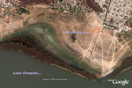
Google Earth view of Lake Chapala
Remember way back in January the photos from Chapala with Ed, Monica, Daniel and Pat. Well I’ve been virtually wandering the planet on Google Earth again and zoomed in on Chapala. Here’s how it looked when you had to walk 1500 yds from the end of the pier to get to the water:

And if you like such things: chapala.kmz google map file
Man. This just shows how grim a satellite picture can be.
For people unable to use Google Earth (like, say, weird Linux users), here’s the same spot in
Google Maps.
Btw, great weblog, Gwyn. You’ve got a new fan here.
Salud!
Gracias Cesar,

No sé cómo te enteraste de mi bloguito, pero yo ya había descubierto el tuyo hace como una semana. Hasta tengo el RSS feed en Thunderbird. ¿Casualidad o alguna tecnologia que todavia no domino? Bueno de todas formas, gracias por el vinculo para los linuxeros y aqui la foto de como deberia de ser hoy. Mas o menos. Viva photoshop!
¡A huevo! ¡Yo sabía que hay un monstruo verde en ese lago! ¡Que no fue una alucinación inducida por la cerveza y el calor!
Je. De cómo te hallé… creo que te encontré en Technorati como el único otro blog etiquetado con “Jalisco”. También me suscribí a tu RSS (yo con un “live bookmark” de Firefox) y luego esta foto que pusiste me llegó y tuve que escribirte.
O algo así.
Gusto en saludarte. Por aquí nos leemos, mi buen.